For further detail and ongoing research see Abbotstone House Research.
 . . .
. . .

.jpg)
Illustration taken from Google Street View (Copyright Google 2012) [I have a photo to replace this with]
Introduction
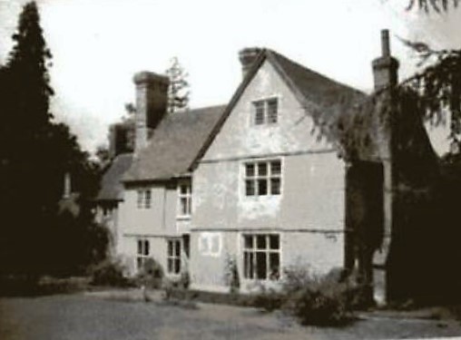
Abbotstone House stands north of the A27 towards the west end of The Street. An imposing building, Matcham (pp39-40), writing in 1844, left a lovely description: "The house, situated in a little dell at the entrance of the village of Whiteparish, with its low but substantial gable and ample casements, is an interesting relic of the old yeoman's establishment, suited to that rank in life which was the envy of the noble Falkland, and which he aptly described as "above the office of Constable, and below that of a Justice of the Peace".
Use of the name "Abbotstone" comes with a complex and fascinating story. Here is a house on the lands of Whelpley Manor that was once the Whelpley Manor House bearing a name that associates it with Abbotstone Manor, while the nearest point in Abbotstone (later known as Titchborne Manor) is across the A36 at the far end of Newton Lane, over a kilometre (nearly two thirds of a mile) from the house.
The origins of the house date back to well before 1627, when it was almost certainly constructed as a new Manor House for Whelpley [Taylor, WAM Vol 62, 1967, p 94 wasn't aware when he wrote his article that the manor house was a 1627 rebuild of an earlier house]. At this time the Lords of Manors with land close to Whiteparish church were relocating into grand houses in what had become Whiteparish village, another example being the 1562 Alderstone St Barbe Manor House, built on Alderstone land just south of the church where the Surgery and Steeple Barn now stand. It is likely that the original building on the Abbotstone House site dates from about the same time.
The Stockman family bought Abbotstone or possibly a Stockman married Eleanora, 13 year old heiress of Richard Light, who died in 1565, and in 1627 one of his descendants, Joseph Stockman of Abbotstone, bought Whelpley Farm as well. At this date Thomas Cable had split Whelpley Manor, selling Whelpley Farm to Joseph Stockman and bequeathing the Whelpley Lord of the Manor title and remaining land to his nephew James Scardivale. As the original manor house stood at the centre of Whelpley Farm, it seems certain that the new manor house, to become Abbotstone House in due course, had already been constructed well before date, leaving the old Manor House at Whelpley as the farm house, or possibly as at Alderstone being demolished when the new house was built. Joseph Stockman, meanwhile, had sold the New House (Titchborne Park) part of Abbotstone Manor to Sir Edward Gorges in 1619 and later sold Dry Farm (now Lower Bush Farm) to John Dove in 1646.
So it was that in 1627 William Stockman rebuilt the earlier timber framed Whelpley Manor House (Abbotstone House) in brick: his initials and the date can be seen on the right gable. At this time he still owned Abbotstone Manor, but this was later sold [check] to the Titchbornes and renamed to Titchborne Manor. Early maps show Abbotstone House as Abbotstone Manor Farm up to the end of the nineteenth century, then Street Farm from early in the 20th century, when the house gained its present name of Abbotstone House. The name Street Farm was used by Matcham in 1844, so the name certainly had a longer pedigree than the maps suggest. The listed building description of its features can be found at the foot of this page.
The house has had further alterations over the years, with the left chimney stack bearing the initials ES and the date 1718. Comparison of the modern photograph at the top of this page with the view from the WI scrapbook below [probably c1952] shows that the right hand chimney was demolished, presumably at some point in the second half of the twentieth century.
Ownership of Abbotstone House
Because Abbotstone and Whelpley had common owners for some of this period, the following ownership sequence, taken from from Matcham page 51 (family tree), covers both Whelpley (shown as W) and Abbotstone/Titchborne (shown as T). Many of these details are repeated in Matcham under both Whelpley and Abbotstone/Titchborne.
- (T) Richard Light, gentleman, in the reign of Elizabeth, held the manor of Tychbourne "of the heirs of Sir William Compton in soccage tenure"
- (T) 1560 Richard Light died. His widow Agnes married John, second son of Thomas Gawen, of Norrington, Esq.
- (T) 1565 Agnes and Thomas Gawen and their daughter Eleanora, aged 13, his heiress lived in Titchborne Manor
- (T) Possibly Eleanora married into the Stockman family of Downton [Matcham p51]
- (W) 1589 Roger Titchborne of Sherfield English bought Whelpley manor and estates on 28th May 31st Elizabeth for £550
- (T) 1619 William Stockman sold Titchborne to Sir Edward Gorges of Longford in consideration of a lease of the parsonage at Britford. Surely this is just Titchborne Park, later Newhouse
- (W+T) 1627 William Stockman bought Whelpley Farm (not Manor) when the farm and manor were separated and sold
- (W+T) 1627 William Stockman rebuilt the earlier timber framed "Alderstone" house in brick; the 1627/WS on the right gable (see above and listed status below) refers to this rebuilding
- (W+T) 1677 Titchborne (and Whelpley?) made over to trustees of the marriage settlement of Thomas Chettle and Constance Stockman his wife (father Joseph Stockman)
- (W+T) Thomas Chettle got an Act of Parliament in 1st William and Mary (1688) to sell part of his estate for payment of debts and to make provision for his wife and children.
- (W+T) 1689 Thomas Chettle sold part of the Titchborne and Whelpley estates to William Seymour (heir of Edward Seymour), his wife Elizabeth and children. Matcham p39: In the schedule of Mr. Chettle's estates, Whelpley farm is stated to contain 287 acres; but the adjoining farm, called Street, for the most part formed a portion of the original demesne.
- (W+T) Whelpley and Titchborne remained with William's son Edward and Mary his wife, then (via the son Sir Henry Monro, son of Edward's sister Mary Seymour and her husband Sir Robert Munro/Munro,... [Matcham shows both Munro and Monro on page 51]
- (W+T) Sir Henry Monro/Munro sold Whelpley and Titchborne to Henry Dawkins, Esq.
- (W+T) 1813 Henry Dawkins died, directing in his will that his estates in Wiltshire should be sold.
- (T) 1813 Titchborne was bought by the trustees of the Nelson property at the same time as Standlynch and other lands in Whiteparish parish.
- (W) 1813 Whelpley Farm was bought by Robert Cooper of Winterslow, including Street Farm and Abbotstone House. Matcham p39: Street Farm, the other property purchased at the same time by Mr. Cooper of the executors of Henry Dawkins, Esq. contains 191a 1r 13p.
- (W) 1844 Robert Cooper's son, also Robert Cooper, owned Whelpley Farm at the time Matcham was writing in 1844.
Abbotstone Manor Farm, Street Farm and Abbotstone House
The WI scrapbook of 1952 referenced by Taylor included three views of Abbotstone House and Street Farm with the following comment: "Built in 1627 it was formerly known as Street Farm. The garden contains a rare form of Scots pine which has grown to an immense size [still there in 2018]. The barn behind the house is where the first Conservative meeting in Whiteparish was held, and where they used later to hold the Conservative dinners." [Check date this caption was added, whether it really is a Scots Pine, add my modern photograph of the pine.
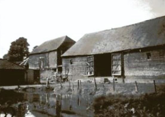
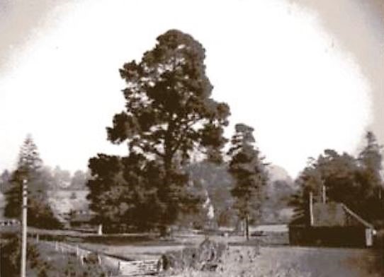
Views of Abbotstone House - the house, the barn, the Pine (from 1952 WI scrapbook)
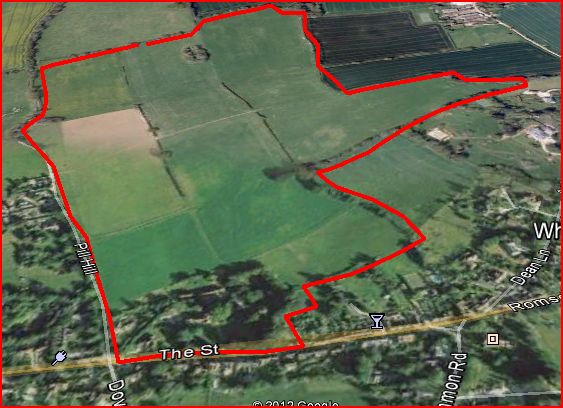
Two houses were built on land taken from the west end of the plot: Springfield between 1966 and 1970 and Remenhan House probably about 1995-2000, visible in the bottom left corner of the aerial view below.
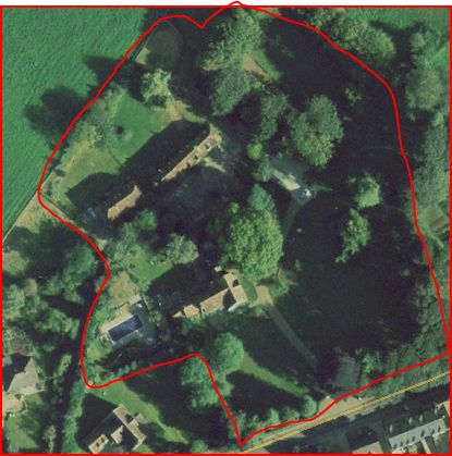
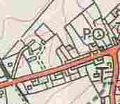
Abbotstone House and associated buildings, Copyright Google 2012
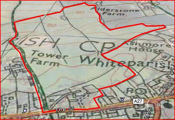
The next maps are taken from the 1842 Tithe map, with Robert Cooper's Street Farm in orange on the first map and the farm buildings ringed in red on the second - Street Farmhouse (later Abbotstone House) is ringed within it. It can be seen from the Google view above that the outline of the plot has changed little save for the building of the two later houses already mentioned. As well as the land leading back away from the A27 behind the property, Robert Cooper also held the Whelpley Estate and a block of land each side of Clay Street reaching almost to Newton Lane. The areas farmed and owned in 1842 were quite close (453.6 and 501.0 acres respectively).
The land associated with Street Farm is part of Whelpley Manor and fronts the western half of the north side of The Street, a feature that almost certainly contributed to the formation of the village, with Alderstone inhabitants on Dean Lane/Ashmore Lane round The Green and along the east end of The Street, and Whelpley ones at the west end.
Two points are worth noticing: firstly the gap introduced by George Yalden Fort's land (green on the map below) between Street Farm and Whelpley Farm, a consequence of the 1804 enclosure of the last parts of Whelpley's common arable fields (details at Tithe Map), and secondly the field called Six Acres that reaches eastwards (top of this map) into the area that might otherwise be expected to be part of Alderstone.
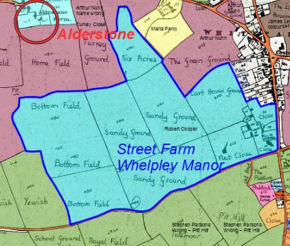
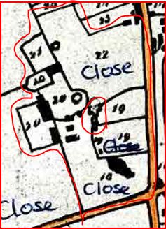

The extent of Street Farm (blue) and detail of the Street Farm buildings on the 1842 Tithe Map
(north at left side of map for the left and central maps, at the top for the right hand map)
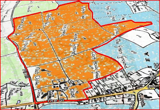
The three perspective views below show Street Farm between Alderstone on the right and George Yalden Fort's land on the left. The first shows the 1842 Tithe map owners, the second a modern 1:25000 OS map and the third the Google Earth view of the same scene. Street Farmhouse, now Abbotstone House, is just above the two parcels marked Close along The Street in the foreground of the first view. In 1842 Robert Cooper owned both Street Farm and Whelpley, and the green land to the left was also part of the Whelpley Manor land before enclosure. Dean Hill Farm is based on what was earlier Sansoms Down.
Street Farm on the 1842 Tithe Map (perspective view from the south with The Street in the foreground)
Street Farm on an old 1:25,000 Ordnance Survey Map (out of copyright)
Street Farm superimposed on a modern Google Earth aerial view (Copyright Google 2012)
Abbotstone House Listed Building Details
Information on historical aspects of Abbotstone House can be found on the listed buildings website at BritishListedBuildings
"Detached house. Late C16, 1627/WS on right gable, ES/1718 on left stack, late C18 and C19 additions. English bond brick, tiled roof, brick stacks. T-plan, hall with cross wing. 2-storey, 5-window front. Round-arched C20 door to right of former hall range, two cross windows to left, 2-light chamfered mullioned and C19 mullioned and transomed window to right cross range. First floor of hall range has 3-brick plat band, 2-light casement, blind window with wavy voussoirs and C19 oriel, cross wing to right has bullnose brick string course to first and attic floors, 3-light mullioned and transomed window and 2-light ovolo-mullioned window with datestone over, dating rebuilding. Attached to left is late C18 range with casements. Large external stack to left of hall range is part of 1718 rebuilding of hall. Right return has external stack, C19 ovolo-mullioned window and casement to ground floor, bullnose string courses and ovolo-mullioned windows to first and attic floors. Rear has 2-storey late C19 services to left, gabled stair turret with 2-light casement to centre and 3-light and 2- light wooden or cast-iron casements to right. Interior: Open fireplaces with chamfered bressummers, planked doors and 4-panelled C19 doors, winding stairs with octagonal newel. First floor bedrooms in cross wing have reset C17 panelling, and exposed timbers indicative of pre-1627 timber-framed house. The 162?iris [sic = 1627/WS as above?] datestone refers to the rebuilding of a timber-framed house in brick, by William Stockman of Barford Park, now demolished. The brickwork is particularly good. (Unpublished records of RCHM (England), Salisbury)."